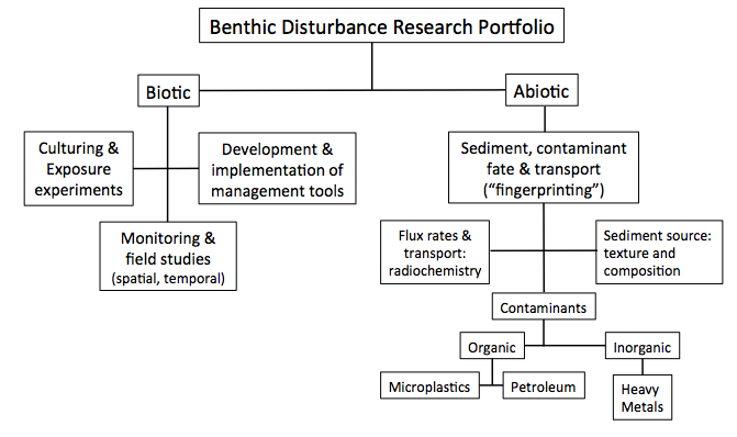
Research Portfolio Flowchart
Research Projects and Groups
As an assistant professor at Eckerd College, I currently have multiple projects in progress with undergraduate student involvement at all stages (from proposal to publication). These projects include:
1. Microplastic abundance and impacts in Gulf of Mexico sediments and benthos
2. Benthic Communities and Endemism at inactive hydrothermal vents and nodule fields: baselines and mining applications
3. Characterizing the naturally occurring radioactive materials (NORM) in produced water from oil and gas wells and their incorporation into fish tissue and sediments
4. Characterizing the formation and evolution of abyssal sinuous channel systems
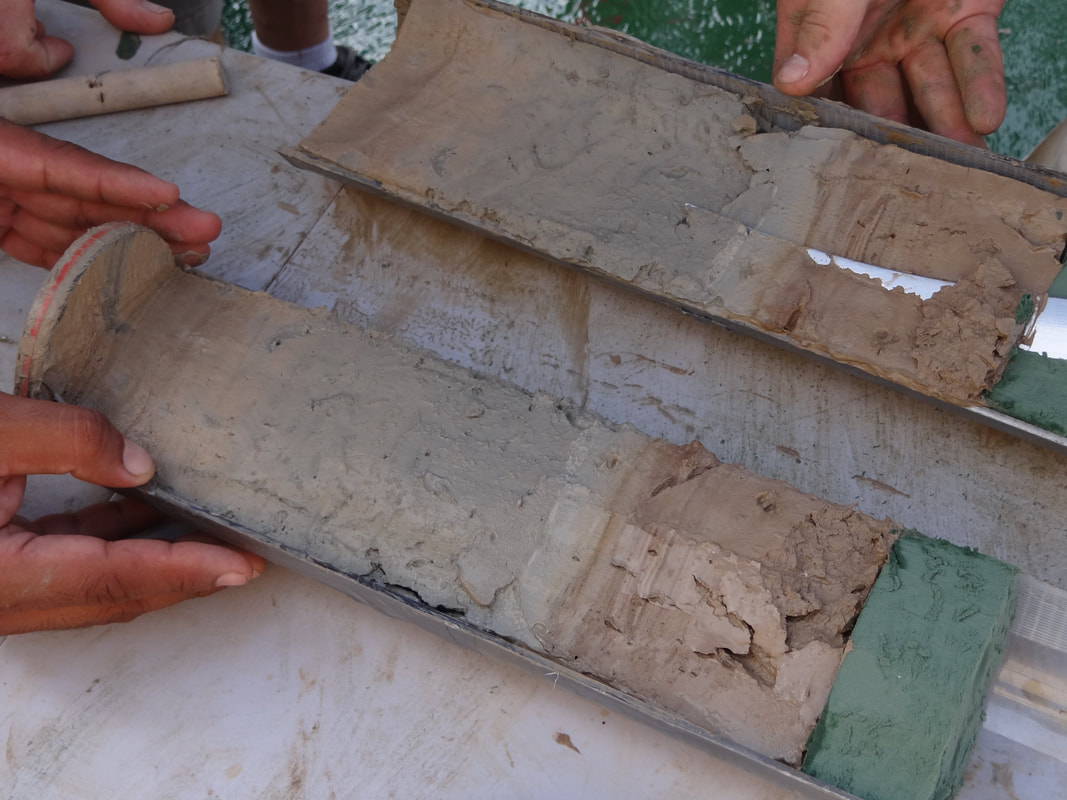
5. Sediment accumulation, burial, mixing and diagenetic rates in Gulf of Mexico Sediments
6. Providing baseline environmental measurements in support of ongoing Harmful Algal Bloom monitoring
7. Development of benthic marine biotic indices to support living resource management decisions
As a student at Eckerd College (2002-2006), I was a member of the GeoCrew, where I Collected vibracores, push cores, diver-assisted push cores, CHIRP sonar data, and surface sediment samples on land and aboard several research vessels including the R/V Gilbert for four regional projects; The Tampa Bay Project, Watersheds of the U.S. Virgin Islands, Hard-bottom research on Rattlesnake Key, FL, and Anoxic cycles of Charlotte Harbor, FL. I also produced a thesis entitled "Regional Climatology and Anthropogenic Impacts on Coastal Sedimentation Patterns: St. John, USVI" and was able to travel to Fiji, Honduras, Antarctica, Cuba, and China for research, educational, and outreach purposes.
1. Microplastic abundance and impacts in Gulf of Mexico sediments and benthos
2. Benthic Communities and Endemism at inactive hydrothermal vents and nodule fields: baselines and mining applications
3. Characterizing the naturally occurring radioactive materials (NORM) in produced water from oil and gas wells and their incorporation into fish tissue and sediments
4. Characterizing the formation and evolution of abyssal sinuous channel systems
5. Sediment accumulation, burial, mixing and diagenetic rates in Gulf of Mexico Sediments
6. Providing baseline environmental measurements in support of ongoing Harmful Algal Bloom monitoring
7. Development of benthic marine biotic indices to support living resource management decisions
As a student at Eckerd College (2002-2006), I was a member of the GeoCrew, where I Collected vibracores, push cores, diver-assisted push cores, CHIRP sonar data, and surface sediment samples on land and aboard several research vessels including the R/V Gilbert for four regional projects; The Tampa Bay Project, Watersheds of the U.S. Virgin Islands, Hard-bottom research on Rattlesnake Key, FL, and Anoxic cycles of Charlotte Harbor, FL. I also produced a thesis entitled "Regional Climatology and Anthropogenic Impacts on Coastal Sedimentation Patterns: St. John, USVI" and was able to travel to Fiji, Honduras, Antarctica, Cuba, and China for research, educational, and outreach purposes.
Nauru Ocean Resources Inc.
The purpose of this research is to satisfy the recommendations of the International Seabed Authority by providing quantitative foraminiferal abundance, biomass, and species structure along with geochemical assessment (XRF, XRD), phytopigment concentration, radioisotope activities and sedimentology that will capture baseline ecological quality for the NORI-D mining exploration area in the Clarion Clipperton Zone (Pacific Ocean). This research will also identify foraminifera bioindicator species as proxies for initial disturbance and plume settling impacts, which will be standardized across campaigns. These bioindicator species will be used to populate and then calculate the Foram-AMBI which can be used to deliver Ecological Quality Statuses for each site.
The purpose of this research is to satisfy the recommendations of the International Seabed Authority by providing quantitative foraminiferal abundance, biomass, and species structure along with geochemical assessment (XRF, XRD), phytopigment concentration, radioisotope activities and sedimentology that will capture baseline ecological quality for the NORI-D mining exploration area in the Clarion Clipperton Zone (Pacific Ocean). This research will also identify foraminifera bioindicator species as proxies for initial disturbance and plume settling impacts, which will be standardized across campaigns. These bioindicator species will be used to populate and then calculate the Foram-AMBI which can be used to deliver Ecological Quality Statuses for each site.
Florida Fish and Wildlife Research Institute
This collaborative effort involves supporting the Florida Fish and Wildlife Conservation Commission-Fish and Wildlife Research Institute’s Harmful Algal Bloom (FWRI-HAB) group by providing benthic/benthos analyses and expertise, and continuing previously established sample collections and associated analysis. These specifically include 1) sedimentological sample analysis of the benthos; 2) producing benthic foraminifera assessments; and 3) evaluating and calculating long-term and short-term flux rates. These efforts are critical to the FWRI-HAB group’s mission, especially in the context of advancing and enhancing bloom modeling and prediction capabilities.
This collaborative effort involves supporting the Florida Fish and Wildlife Conservation Commission-Fish and Wildlife Research Institute’s Harmful Algal Bloom (FWRI-HAB) group by providing benthic/benthos analyses and expertise, and continuing previously established sample collections and associated analysis. These specifically include 1) sedimentological sample analysis of the benthos; 2) producing benthic foraminifera assessments; and 3) evaluating and calculating long-term and short-term flux rates. These efforts are critical to the FWRI-HAB group’s mission, especially in the context of advancing and enhancing bloom modeling and prediction capabilities.
National Science Foundation, GEOPAths: Scientist at Sea Program
This project revolves around a new applied research course program entitled “Scientist at Sea” (S-A-S), to be offered at Eckerd College, including a research cruise experience, peer mentorship and professional productivity opportunities, that encompass practical applied skills for planning, execution, and professional products associated with research. These courses build upon and utilize on-going interdisciplinary research in geosciences that also include biology and chemistry elements. The S-A-S course program consists of a Spring into Summer course that includes the on-campus “pre-expedition” course (Spring) and “at Sea” research cruise (Summer) that is followed by the on-campus “post-expedition” course in the Fall.
This project revolves around a new applied research course program entitled “Scientist at Sea” (S-A-S), to be offered at Eckerd College, including a research cruise experience, peer mentorship and professional productivity opportunities, that encompass practical applied skills for planning, execution, and professional products associated with research. These courses build upon and utilize on-going interdisciplinary research in geosciences that also include biology and chemistry elements. The S-A-S course program consists of a Spring into Summer course that includes the on-campus “pre-expedition” course (Spring) and “at Sea” research cruise (Summer) that is followed by the on-campus “post-expedition” course in the Fall.
National Oceanographic and Atmospheric Administration (NOAA)
Surveillance of Pollution from Emerging Chemical Threats in Tampa Bay. Increasingly, there is concern not only for the proliferation of man-made and natural chemical threats to coastal biota and human health, but also in the potential for synergistic effects among chemicals and with the effects of climate change and other consequential environmental stressors. The proposed project will study a large urbanized estuary on the west coast of Florida (Tampa Bay – TB) to investigate all major classes of contaminants of emerging concern (CECs), and a number of contaminants of known concern (CKCs), to characterize the distribution, concentration and seasonality of such chemicals and their potential threats to wildlife and humans. Additionally, the project will pinpoint the source origins and fates of such chemicals, describe the decadal scale depositional histories of chemicals into Bay sediments, and conduct surveys of human subpopulations that may be at particular risk from these chemical pollutants. These data will be used to inform human risk assessments for consumption of seafood harvested within the Bay and more broadly be used by environmental managers to inform policy and regulatory decision-making with respect to point and non-point source pollution abatement and health advisories.
Surveillance of Pollution from Emerging Chemical Threats in Tampa Bay. Increasingly, there is concern not only for the proliferation of man-made and natural chemical threats to coastal biota and human health, but also in the potential for synergistic effects among chemicals and with the effects of climate change and other consequential environmental stressors. The proposed project will study a large urbanized estuary on the west coast of Florida (Tampa Bay – TB) to investigate all major classes of contaminants of emerging concern (CECs), and a number of contaminants of known concern (CKCs), to characterize the distribution, concentration and seasonality of such chemicals and their potential threats to wildlife and humans. Additionally, the project will pinpoint the source origins and fates of such chemicals, describe the decadal scale depositional histories of chemicals into Bay sediments, and conduct surveys of human subpopulations that may be at particular risk from these chemical pollutants. These data will be used to inform human risk assessments for consumption of seafood harvested within the Bay and more broadly be used by environmental managers to inform policy and regulatory decision-making with respect to point and non-point source pollution abatement and health advisories.

SMARTEX
Within an area of over 6 million square km called the Clarion Clipperton Zone (CCZ) in the central Pacific Ocean, at abyssal depths of almost 5,000 metres, lies a vast mineral resource of polymetallic nodules. The nodules that carpet the seafloor of this area are highly enriched in metals of significant importance for industry, including the development of new sustainable technologies. The Seabed Mining and Resilience To EXperimental Impact (SMARTEX) project will research the baseline environment in regions of the CCZ selected for mineral exploration and evaluate the long-term impacts of mining. This project will provide critical scientific understanding and evidence to reduce the risks of future industrial development on the marine ecosystem within this region.
Key aims:
1. Understand the remaining impact of a realistic mining test on the seabed environment and its fauna after 44 years. We plan to revisit the OMCO (Ocean Minerals Company) test mining area where an experimental mining system was tested in 1979 creating tracks on the seafloor.
2. Assess natural temporal change in faunal communities between 1989 and 2023.
Funding for the SMARTEX project is provided by the UK’s Natural Environment Research Council
Florida Department of Environmental Protection
This effort investigated potential impacts to the benthos and to fishes from the Piney Point effluent release into Tampa Bay in 2021 with the goals of 1) providing environmental context (sedimentology) of the benthos and identifying any physical change to the benthic environment of Tampa Bay; 2) establishing benthic baselines, and assessing any impacts and responses utilizing benthic foraminifera based monitoring tools and bioindicators of ecological quality status, 3) analyzing sediments for a potential elevation in radioisotopes associated with the effluent, and utilize radioisotopes as tracers of the effluent release to establish the benthic spatial distribution and incorporation into the benthos and 4) analyzing fish tissue samples to assess potential elevation in radioisotopes associated with the effluent.
This effort investigated potential impacts to the benthos and to fishes from the Piney Point effluent release into Tampa Bay in 2021 with the goals of 1) providing environmental context (sedimentology) of the benthos and identifying any physical change to the benthic environment of Tampa Bay; 2) establishing benthic baselines, and assessing any impacts and responses utilizing benthic foraminifera based monitoring tools and bioindicators of ecological quality status, 3) analyzing sediments for a potential elevation in radioisotopes associated with the effluent, and utilize radioisotopes as tracers of the effluent release to establish the benthic spatial distribution and incorporation into the benthos and 4) analyzing fish tissue samples to assess potential elevation in radioisotopes associated with the effluent.
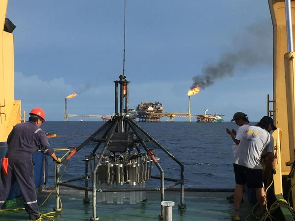
REDIRECT: Resuspension, Redistribution and Deposition of Deep Water Horizon (DwH) Recalcitrant Hydrocarbons to offshore Depocenters
The research team proposes a geospatial, sedimentological, and geochemical approach to study the fate of the Deepwater Horizon (DwH) marine oil snow (MOS) deposited during the Marine Oil Snow Sedimentation and Flocculent Accumulation (MOSSFA, (1)) event on the seafloor in offshore waters of the Gulf of Mexico (GoM). The central hypothesis of the proposed research is that recalcitrant compounds from the deposited oil still remain on the seafloor ~7 years after the DwH spill, however, their spatial distribution and concentration do not correspond with the distribution of the surface oil slick or the subsurface plume due to resuspension and redistribution following initial deposition on the seafloor. Natural heterogeneity of bottom topography and circulation processes are key drivers transporting materials to deeper areas in the GoM by erosion and deposition of contaminated sediments beyond the surface extent of the once existing oil slick or the subsurface plumes(s). The results obtained in this effort will illuminate the fate of the oil released during the DwH oil spill, which is important for developing new mitigation strategies for future submerged spills in the GoM and worldwide. The seafloor depositional environment is highly diverse, which should result in a non-homogeneous distribution of material delivered from the overlying water column. Seafloor sediment is affected by currents, bottom morphology, and physical forcing events of different temporal and spatial scales that rework deposited material within the Bottom Nepheloid Layer (BNL). We hypothesize that the area of seafloor that was affected by deposition of oil from the spill is larger than the area of the surface slick extending into “downhill” areas on the seafloor (>1,500m) that have not been considered as having been affected by oil derived hydrocarbons. Through down-gradient transport, material will follow pathways based on the highly variable seafloor morphology, with its hills, slopes and canyons, allowing for erosion and deposition beyond the spatial extent of the once existing oil slick or subsurface plumes(s), and beyond the distributions mapped in the year following the spill, thus potentially affecting an area much larger than originally described and has been sampled to date (e.g. (2, 3).
The research team proposes a geospatial, sedimentological, and geochemical approach to study the fate of the Deepwater Horizon (DwH) marine oil snow (MOS) deposited during the Marine Oil Snow Sedimentation and Flocculent Accumulation (MOSSFA, (1)) event on the seafloor in offshore waters of the Gulf of Mexico (GoM). The central hypothesis of the proposed research is that recalcitrant compounds from the deposited oil still remain on the seafloor ~7 years after the DwH spill, however, their spatial distribution and concentration do not correspond with the distribution of the surface oil slick or the subsurface plume due to resuspension and redistribution following initial deposition on the seafloor. Natural heterogeneity of bottom topography and circulation processes are key drivers transporting materials to deeper areas in the GoM by erosion and deposition of contaminated sediments beyond the surface extent of the once existing oil slick or the subsurface plumes(s). The results obtained in this effort will illuminate the fate of the oil released during the DwH oil spill, which is important for developing new mitigation strategies for future submerged spills in the GoM and worldwide. The seafloor depositional environment is highly diverse, which should result in a non-homogeneous distribution of material delivered from the overlying water column. Seafloor sediment is affected by currents, bottom morphology, and physical forcing events of different temporal and spatial scales that rework deposited material within the Bottom Nepheloid Layer (BNL). We hypothesize that the area of seafloor that was affected by deposition of oil from the spill is larger than the area of the surface slick extending into “downhill” areas on the seafloor (>1,500m) that have not been considered as having been affected by oil derived hydrocarbons. Through down-gradient transport, material will follow pathways based on the highly variable seafloor morphology, with its hills, slopes and canyons, allowing for erosion and deposition beyond the spatial extent of the once existing oil slick or subsurface plumes(s), and beyond the distributions mapped in the year following the spill, thus potentially affecting an area much larger than originally described and has been sampled to date (e.g. (2, 3).
CIMAGE III: Advancing the understanding of the processes, mechanisms, and environmental consequences of marine oil blowouts
C-IMAGE (the Center for Integrated Modeling and Analysis of Gulf Ecosystems) is a marine research consortium funded by the Gulf of Mexico Research Initiative (GoMRI) following the 2010 Deepwater Horizon oil spill.
C-IMAGE focuses on:
C-IMAGE (the Center for Integrated Modeling and Analysis of Gulf Ecosystems) is a marine research consortium funded by the Gulf of Mexico Research Initiative (GoMRI) following the 2010 Deepwater Horizon oil spill.
C-IMAGE focuses on:
- 1. Improving observational and predictive tools for oil spills,
- 2. Understanding the Deepwater Horizon and Ixtoc I oil spills, and
- 3. Predicting consequences of another deep-sea oil blow out. Our 19 research partners study a variety of factors effecting the behavior and consequences of oil spills including: dispersants, fish health (field and experimental studies), Gulf-wide impacts and new baselines, oil and methane gas behavior and evolution at high-pressures, seafloor impacts and recovery, biodegradation, ecosystem models, deep-diving whales and dolphins, and reef community changes C-IMAGE is a Gulf of Mexico Research Initiative (GoMRI) funded consortium since 2011 and has been refunded through 2019.
The focus of the Center for Integrated Modeling and Analysis of Gulf Ecosystems II (C-IMAGE II) is to advance understanding of the processes, mechanisms, and environmental consequences of marine oil blowouts. New to the Center are three novel projects focused on establishing ecological baselines in the case of another Gulf spill. These projects include:
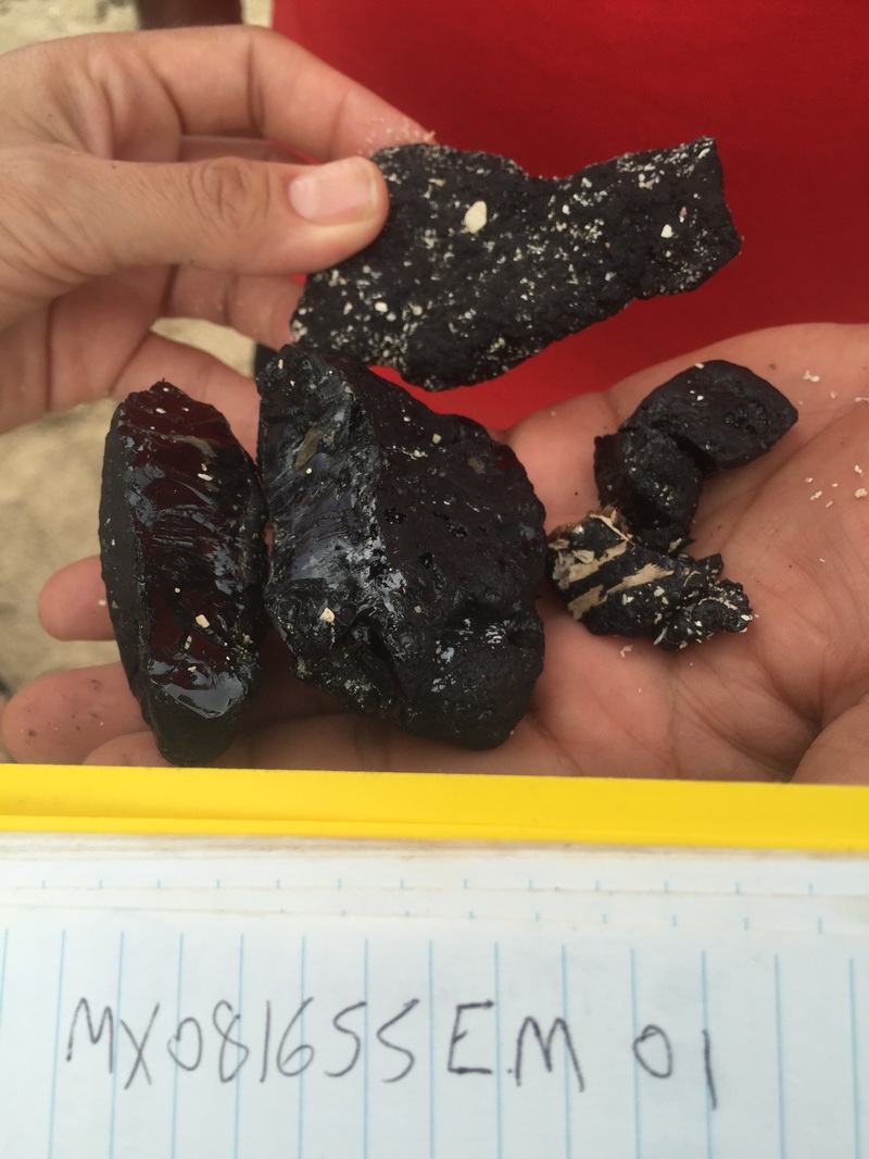
The Ixtoc-I oil spill began on June 3rd, 1979 in the Bay of Campeche, 100 km NW of Ciudad de Carmen, Mexico. Nine and a half months later, the well head was capped and flow stopped, but not after an estimated 126 to 210 million gallons of oil leaked into the southern Gulf of Mexico; compare this to the three month uncontrolled blowout and 107 to 184 million gallons of Deepwater Horizon.
- Controlled exposure studies of adult fish assessing the chronic vs. episodic oil pollution uptake
- Predict the long-term fate and degradation of oil on Gulf ecosystems using sediment cores from parallel Gulf spills
- Establish fish and sediment baselines by conducting the first Gulf-wide assessment along the continental shelf.
The Ixtoc-I oil spill began on June 3rd, 1979 in the Bay of Campeche, 100 km NW of Ciudad de Carmen, Mexico. Nine and a half months later, the well head was capped and flow stopped, but not after an estimated 126 to 210 million gallons of oil leaked into the southern Gulf of Mexico; compare this to the three month uncontrolled blowout and 107 to 184 million gallons of Deepwater Horizon.
The Center for Integrated Modeling and Analysis of Gulf Ecosystems (C-IMAGE) is a research consortium of 19 U.S. and international partners focused on effects of oil spills on marine environments. Beginning in 2011, C-IMAGE received funding from GoMRI to study the processes and effects of the BP oil spill on the Gulf of Mexico. With help from domestic and international partners, we began studying the physical, chemical, and biological processes occurring when oil and dispersants are introduced to a marine ecosystem. Our consortium began connecting researchers across disciplines and academic institutions to create a holistic view of marine environments during and after oil spills. Through high-pressure experiments, calibrated modeling, and field research, C-IMAGE has laid a foundation for future research throughout the Gulf of Mexico.
The Deep-C (Deep Sea to Coast Connectivity in the Eastern Gulf of Mexico) Consortium was a four-year, interdisciplinary study of deep sea to coast connectivity in the northeastern Gulf of Mexico. The study, which began in 2011, investigated the environmental consequences of petroleum hydrocarbon release in the deep Gulf on living marine resources and ecosystem health. Deep-C examined the geomorphologic, hydrologic, and biogeochemical settings that influence the distribution and fate of the oil and dispersants released during the Deepwater Horizon (DwH) accident, and used the resulting data for model studies that support improved responses to possible future incidents.
While at USF, College of Marine Science, as a Ph.D. student and postdoctoral scholar, I managed the Radiogeochemistry laboratory and worked in the Paleoceanography and Biogeochemistry Laboratory (Paleolab), I primarily worked on my thesis entitled "A Sedimentary Record of Regional Land-Use and Climate Change in the Manatee River, Manatee County, Florida." However, I was also heavily involved with several other projects including:
1. Dry Tortugas National Park Seafloor Mapping
-Acquired sidescan and high-resolution bathymetric imagery of the Dry Tortugas National Park (DRTO) used for mapping topography and benthic habitat in the deeper areas of DRTO that are not imaged by other methods such as LIDAR or aerial photos aboard the R/V Bellows.
2.West Florida Shelf Ocean Acidification (2008)
-Determined the CO2 enrichment, organic content and carbonate content from surface sediment samples, and SEAS chemical parameter measurements along the West Florida Shelf aboard the R/V Suncoaster.
3. Radiogeochemistry of Puerto Rico (2008)
-Co-coordinated the push-core, surface sediment sampling, and water quality assessment of terrestrial and marine sites in Jobos Bay and El Yunke National Park.
4. Florida Straits Side-scan Sonar Survey (2008)
-Surveyed several previously unmapped seafloor features of interest using a pole-mounted Teledyne-Benthos C3D interferometric sidescan sonar aboard the R/V Bellows
